
Contact Details:
EngNet - Engineering Network
11121 Carmel Commons Blvd.
Charlotte
NC
28226
United States of America
Tel: +01 704 5413311
Fax: +01 704 9430560
Send Enquiry | Company Information
Why NASA Is Flying Drones Into Hurricanes?
Product News Thursday, September 6, 2012: EngNet - Engineering Network
As Gulf Coast residents patch up windows and shovel dead rats off beaches following last week's Hurricane Isaac, NASA is preparing to launch its most ambitious mission yet to study hurricane formation. The Hurricane and Severe Storm Sentinel, or HS3, is a five-year, $30 million project to fly unmanned aircraft laden with scientific instruments into and around developing hurricanes. Beginning this month, the planes will gather data for three September-to-October hurricane seasons and should help scientists better understand how the storms are whipped up — and why they sometimes turn deadly fast.
Over the past few decades, meteorologists have learned how to predict hurricanes' trajectories with impressive accuracy. But changes in their intensity are still very difficult to anticipate. Some storms, such as hurricanes Katrina and Rita in 2005, intensify rapidly. Their wind speeds increased by at least 30 knots in 24 hours, taking them from moderate to devastating over just one day. Others, such as Isaac, remain relatively moderate.
When it comes to predicting which storms will turn ugly, "there's been almost no improvement over the last 20 years or so," says Scott Braun, a meteorologist at NASA's Goddard Space Flight Center and the principal investigator for HS3. That's because unlike a storm's path, which depends mostly on large-scale air currents in the surrounding atmosphere, a hurricane's intensity depends on complicated interactions between the atmospheric conditions and smaller-scale forces within the storm itself.
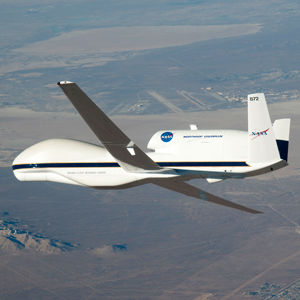
That's where the drones come in. HS3 employs two Global Hawks—unmanned, high-altitude planes that can fly for up to 30 hours at a time carrying a suite of sophisticated instrumentation. The Global Hawks can reach altitudes higher than 55,000 feet—about 20,000 feet higher than a typical commercial airline flight, and high enough to cruise over the tops of churning storms. The planes will launch from Goddard's Wallops Flight Facility on the Eastern Shore of Virginia.
Hurricanes that hit the eastern U.S. get their start on the other side of the Atlantic. So the first HS3 drone will sweep the areas around storms in their very early stages and use sensors to measure temperature, humidity, and wind and dust activity in the surrounding environment. The HS3 team is especially interested in using this plane to study the Saharan Air Layer (SAL), a mass of hot, dry, dusty air that rises off the African desert and blows west across the Atlantic. Early studies of the SAL suggested that it contributes to developing storms. More recently, scientists have argued that it seems to suppress them. By closely monitoring the SAL and its activity as storms pop up, Braun says, HS3 should be able to help nail down its role.
The second aircraft will fly directly above storms as they brew and intensify. It will be outfitted with radar instruments that can see through the storm to take 3-D measurements of wind and precipitation, sensors to track temperature and humidity, and an instrument called a Hurricane Imaging Radiometer, which will map out winds at the ocean's surface by measuring the microwaves naturally emitted by the sea foam wind churns up. Among other things, the over-storm plane will look for the massive columns of thunderstorms, or "hot towers," that sometimes form inside hurricanes. Meteorologists have noticed that hot towers often form before a hurricane intensifies, but it's unclear whether they're actually stoking the storm or merely popping up as it gathers more energy from somewhere else.
NASA flew one of the Global Hawks in a previous hurricane-sleuthing mission in 2010. But there were serious limitations. At the time, the drone had to fly out of NASA's Dryden Flight Research Center in California, because Dryden was the only place with the necessary infrastructure to pilot the plane remotely. That meant the Global Hawk ate up much of its flight time just getting to the East Coast and back, and couldn't venture far beyond the mid-Atlantic and Gulf of Mexico, where storms often arrive fully formed. This time, NASA will launch the drones from Virginia, where the agency has set up a mobile operations center to pilot the drones and will build a permanent one by next year. That means the planes can travel all the way across the ocean to where the hurricanes are born. "We can basically fly to the west coast of Africa, hang out for 6 hours, and then come back," Braun says.
The first Global Hawk is scheduled to arrive at Wallops this week, and the second will follow soon after. Once the planes take off, you can follow their flight paths from home on NASA's Aircraft Tracker map. They'll fly for an abbreviated season of three or four weeks this year, largely to work out the operational kinks. But the HS3 team hopes to sample at least two hurricanes this season—weather permitting, of course—and the first flights should prepare them well for the next two years, when the drones will spend a full four or five weeks in the field.
With any luck, the intel they bring back will help make hurricanes' development a bit less cloudy.
Source: http://www.popularmechanics.com/science/environment/natural-disasters/why-nasa-is-flying-drones-into-hurricanes-12437824